 |
Acadia National Park - Mt. Desert Island, Maine
Copyright Andy Richards 2009 - All Rights Reserved |
I have visited Acadia once. I hope to get back again one day. Like so many destinations in the northeastern U.S. It seems like fall is the best time to visit, so it will likely be during that time of the year. There is just so much color in these park settings.Acadia started out as Sieur de Monts National Monument in 1916. In 1919 Congress designated the area as a National Park, and the name was changed to Lafayette National Park. In 1929 the name was changed again to Acadia National Park.During the 1800's a large number of wealthy folks from some of the east coast's more populous areas migrated up to the area (Mount Desert Island) and constructed large summer residences. This construction eventually put stress on the infrastructure and natural resources of the island and a few civic-minded individuals began to try to manage the growth, creating civic organizations focused on preservation of the surrounding natural beauty. Eventually these groups began to raise funds and came up with the idea of purchasing tracts of land to be donated as National Park grounds. They were soon followed by other philanthropists (including - notably - John D. Rockefeller) who either already owned land or had the wherewithal to purchase them. Thus, Acadia became the U.S.'s first national park to be formed primarily from donated lands. With a mix of rugged "downeast" Atlantic shoreline, forests and mountain, the park is truly a photographic wonder.
Where To Stay - Bar Harbor. There is really only one place that truly makes sense to stay and use as a base of operation: Bar Harbor. This picturesque little coastal town immediately adjacent to the Park (much of the park is actually within the town borders) has a year-round population of around 5,000, but swells to more than 4 times that size during the summer months. Currently built for tourism, the very small, quaint downtown has numerous shops and restaurants, with the main street terminating at the harbor. There are several hotels along Main Street, but we found (and I would recommend) an Inn just a block or two off Main. This was back in 2009, so today, a VRBO type property would probably also make some sense. Everything is very close, so getting into the park from our location took mere minutes.
There are a few nice restaurants in Bar Harbor, but depending on the time of year you visit, be aware that many of them are seasonal. We arrived a bit late (due to some personal scheduling concerns - I would like to have been about a week earlier), on October 25th and lots of things were closed down. We got lucky and hit one of the well-known lobster restaurants, on its last night of the season, so at least we had one of those famous full lobster dinners. There climax is the Columbus Day weekend, and they go into winter mode soon after that. But there will still be places that are open. We had no issues finding restaurants and getting food. I did have, however, one regret. I had read about the little wharfside shacks where the fishermen bring their catch in to the "Lobster Pounds" to be held and eventually trucked away. The shacks, I understand, during the summer months, sell fresh lobster rolls in a "take-away" fashion. Back in 2009, they were said to be relatively inexpensive. By October 25, though, they were all closed. Bummer.
 |
Cruise Ship - Bar Harbor, Maine
Copyright Andy Richards 2009 |
The flip side of that, of course, is that if you are there "in season," you will have to work around crowds of tourists, including - these days - the cruise ships that stop in Bar Harbor a couple days a week during the summer months. We had the park virtually to ourselves the entire week and that was nice.
Getting to Bar Harbor. There really are no choices. You pretty much must get on U.S. Route 1 somewhere, and the get off it north of Mt. Desert Isle at Maine 13, heading south and then eventually east to Bar Harbor (all on 13). 13 becomes Eden Street as you enter town. You can see from a map that there are a couple roads that circle and cross Mt. Desert Island, and you will learn soon enough, how to get around the island.
Getting Around. The Park Loop Road is probably the best way to see the park, for the most part. You can access it in several spots in and around Bar Harbor, and follow it through the park to most of the features and "iconic" views. There are a couple of "hidden gems, also."
I used the "vicinity" label in the title purposely. When we first planned our visit to the park, we read books about the park - some by photographers. We learned that many of the really photogenic spots in the area are not necessily within the main park (Loop Road), but the small, mostly lobster fishing, towns around Mt. Desert Island - and in a few cases even off the island. I probably made some of my most memorable photos in these areas, so I will cover the ones I know about here, too. It may depend on how long you spend in the area. We spent a week, which gave us plenty of opportunity to explore outside the primary park.
The Park
As I noted above, there are a multiple entrance points to the Park Loop Road as it circles around the park. To the best of my memory most of them are not gated, so you can get in the park before first light. There is a "main" entrance just south of town. You will need to purchase a Park Pass (at last check $35/vehicle for a 7 day pass). Grab a map, which should show the other entrances, but they are also well marked and the Loop Road is pretty identifiable. The only confusing part is that some of the Loop Road is one-way and some is two-way. Figuring out how to get turned around take a bit of "practice."
 |
Along the Acadia National Park Loop Road - Mt. Desert Island, Maine
Copyright Andy Richards 2009 - All Rights Reserved
|
Along the Loop Road, there are a couple of "not to miss" photo-ops. But there are perhaps just as many spots where you can pull off and just walk around and explore with your camera. And sometimes you will just see something along the road that will compel you to stop and get out and shoot. I will enumerate a couple of the "not-to-miss" shots below, but don't be so rigid in your pursuit of those shots that you miss some of the other opportunities.
 |
Carriage Road - Acadia National Park - Mt. Desert Island, Maine
Copyright Andy Richards 2009 - All Rights Reserved |
Crossing the Loop Road in numerous places are "carriage roads." These "unimproved" roads can yield some nice shots in fall color. But maybe even better for photography are the brick masonry bridges that cross the Loop Road in various places. I encourage you to stop and park somewhere and just wander these roads.
 |
Carriage Road Bridge crossing the Park Loop Road - Acadia National Park - Mt. Desert Island, Maine
Copyright Andy Richards 2009 - All Rights Reserved |
The Bubbles
This shot, on Jordan Pond in the middle of the park is much-publicized. It is one of those potentially magical opportunities that really requires Mother Nature to be in a cooperative mood and bring a lot of things together. We didn't get that on this trip. During many of the days it was windy and we weren't able to get a nice, still shot of the pond, with reflections. My friend, Carol Smith has a shot where she recorded some wonderful reflections, including in the water at the immedate foreground of her shot. You can see there is a walking path of to the left. That path goes all the way down to the water's edge. Ideally, I would get down there, with my camera as close to the water as possible, using a low point of view and a wide angle lens, and try to get those twin peaks more a main feature of the shot. But with the dark blue and wind and waves, that just didn't work for me that day. I moved back away from the water for a wider shot, hoping to make something more interesting in the foreground (I am not sure I suceeded). Still, you can see there are some opportunities there if you hit it right.
 |
Jordan Pond and "The Bubbles" - Acadia National Park - Mt. Desert Island, Maine
Copyright Andy Richards 2009 - All Rights Reserved |
Thunder Hole
(Accessed from the Loop Road) This is another well-publicized scene in the park, this time on the rocky shoreline of the Atlantic. This is a small promontory that has formed, over 100's of years of crashing wave action, an indentation in the rocks. When the waves crash in, they make a crack that sounds like thunder. This is a challenging scene to try to photograph. If you google it, you will see some "record" type shots from up above showing the crashing waves. There is a small fenced observation area right down on top of the hole, but only when the seas are relatively calm would it be safe to go down there - and you are still pretty assured of getting (you and your gear) wet. Seas were rough enough during our visit that it was not possible to go down close - and we judged it too difficult to find a good angle to photograph it. As they say: YMMV. This spot did inspire me to spend some time one afternoon along the rocky shoreline near there, shooting the breaking waves on the rocks. Fun, and mesmerizing for me.
 |
Crashing Waves on the shoreline - Acadia National Park - Mt. Desert Island, Maine
Copyright Andy Richards 2009 - All Rights Reserved |
Otter Cliff
(Accessed From the Loop Road) This is yet another well-know and often photographed spot in the park, this time, just a bit further down the shoreline (3/4 mile) on the Loop Road fromThunder Hole. There is an observation point there. I didn't really make any shots from there, as we were there at mid-day with marginal light and I didn't see anything that made me feel compelled to shoot. It is a nice spot and that could change dramatically with differences in light and weather.
Boulder Beach
This is one of the sort of "hidden secrets" I alluded to earlier. About half-way between the Thunder Hole and Otter Cliff observations points, there is a small parking area on the west side of the road. From there, you can walk onto the "Ocean Path" walkway and walk quite a distance in either direction. If you walk out and a bit north, and turn around and look south, you will see the view of Otter Cliff in the distance. When the sunrises on a good day, it lights up Otter Cliff nicely - sometimes even dramatically. That is where 95% of photographers make their shot. You can see down to the boulder beach but it isn't apparent that that is what a lot of us who have been there believe is the better sunrise shot of Otter Cliff. The way down is a bit of a scramble, and walking over the small cobbles (boulders?) can be a bit treacherous, but it will be worth it. Wear appropriate supportive footwear. There is a small, not very well marked, pathway down the bank just opposite the intersection where Otter Cliff Road comes onto the Loop Road. Carefully scramble down there and prepared to be rewarded with your initiative. We found it during daylight hours and then were down there for two sunrises.
 |
Otter Cliff Sunrise - Boulder Beach - Acadia NP - Bar Harbor, ME
Copyright Andy Richards 2009 - All Rights Reserved |
Sand Beach
Up at the northern end of this section of the park, tucked away in a cove that is protected by another point to its east, is Sand Beach. There is a large parking lot there, with a pathway down to a wide, beautiful, sandy beach (not a common ocurrence on the northeast Atlantic in my experience). This is also where the trailhead to the Ocean Path mentioned above is. I photographed it from up on the Ocean Path, a fair distance south of the beach. In warmer weather, I imagine it would look quite different.
 |
Sand Beach - Acadia National Park - Mt. Desert Island, Maine
Copyright Andy Richards 2009 - All Rights Reserved
|
Cadillac Mountain
Another very popular photo spot, Cadillac Mountain is not without its photographic challenges. The summit of this mountain sees the very first peek at the sunrise in the U.S. But unless you want to hike up there, you are probably not going to see it. The gates at the bottom open at sunrise, and there is usually a line of traffic. We were there - again - in the offseason so it wasn't jam-packed. But my understanding it is during the season. So much so that in recent years, driving up there at all requires a prior reservation - and they are limited. There is no doubt the view up there is spectacular. But no more so than other summits I have been on over the years. If you can get up there, you should probably try. If not, I would't lose any sleep over it. There are better photo opportunities here. As is often the case, lighting is critical and my shot is made in less than spectacular light. Note also, that there is not much up there to use in your foreground to give the shot some depth. So unless you can get there when something is happening out to sea, you may not fare any better than I did.
 |
Bar Harbor (from Cadillac Mountain summit) - Acadia National Park - Bar Harbor, Maine
Copyright Andy Richards 2009 - All Rights Reserved |
Directions. Take Eagle Lake Road (233) west out of Bar Harbor for just over a mile. Turn onto the Park Loop Road (south) and continue on for another mile to the Cadillac Mountain Summit Road. The winding drive up is just over 3 miles.
 |
Ocean Walkway - Acadia National Park - Mt. Desert Isle, Maine
Copyright Andy Richards 2009 - All Rights Reserved |
In the Park itself, I cannot think of any other "iconic" shots. But you should have no problem finding your own shots. You can spend hours on the Loop Road, both out along the rocky coastline and in some of the inner sections of the park. Get out. Walk around and explore. We found the little double waterfall and bridge by doing just that.
 |
Waterfall - Acadia National Park - Mt. Desert Island, Maine
Copyright Andy Richards 2009 - All Rights Reserved |
"Vicinity"
I think we spent equally as much time outside of the park as we did in. One reason for that is that I have an affinity for working boats and fishing harbors. What is especially unique about most of these places in Maine is that they specialize in Lobstering. Not that it is so much different from other fishing, but there seems to be a great parallel to small operations and the small family farms I grew up working on.
 |
Lobster Fishing - Bernard, Maine
Copyright Andy Richards 2009 - All Rights Reserved |
On its south end, Mt. Desert Island is split (nearly in half) by the long Somes Sound. Especially on the south side, there are several notable lobster harbors/lobster fishing villages, including Seal Harbor, Northeast Harbor, Southwest Harbor, Bass Harbor and Bernard. We drove to all of them. Some of them yielded some great photographs. Others, not so much, but we had to check them out. Here are the ones we felt were most worth seeking out. On the southeast end of Mt. Desert Island and the east side of the Somes Sound, there are only two we visited: Seal Harbor and Northeast Harbor. Neither got our juices running and there didn't really seem to be as active a fishing industry in either of them. Seal Island is small, and in recent times, has positioned itself as a summer retreat for "the rich and famous." We didn't see much of the blue collar fishing industry evidenced. Northeast Harbor was similar, with lots of evidence of affluence including the more expensive pleasure boats in the harbor.
NOTE: You may notice as you read on that most of our images are from harbors on the western side of the water. There is no happenstance here. We did not generally get out to these harbors in the early mornings, preferring to get sunrise and morning images "closer to home." The afternoon sun lit the scenes we took from the west nicely.
 |
Wild Blueberries in the Fall - Mt. Desert Island, Maine
Copyright Andy Richards 2009 - All Rights Reserved |
While driving these roads, if you are there in the fall, keep a sharp eye peeled for bright red blooms of wild blueberry bushes like the ones in the image above. Indeed, Maine is known as the wild blueberry capital of the world.
"You can't get there from here"
For us, the best "fodder" turned out to be on the other side of The Somes Sound, in Bass Harbor (for the Bass Harbor Light), Southwest Harbor, and Bernard. These latter two were most clearly "blue collar" serious lobster fishing territory.
Southwest Harbor
Directions. Just 2 miles from Northeast Harbor as the proverbial crow flies, that will only work for you if you have a boat. It is a straight shot slightly southwest across The Somes Sound from Northeast Harbor to Southwest Harbor. If you have to travel by car, it is 12 miles (all the way up The Somes Sound, across it, and all the way back down again). If you are going to skip Northeast Harbor (and for photographs, I probably would), It is just 6 miles from Bar Harbor to the turnoff to go to the west side of the sound. About 12 miles from Bar Harbor down to Northeast Harbor. Just slightly more (14 miles) from Bar Harbor to Southwast Harbor. Worth the drive!
 |
Southwest Harbor, Maine
Copyright Andy Richards 2009 - All Rights Reserved |
On your way down there, by the way, you will pass through the little "berg" of Somesville and the very picturesque (and oft photographed) Somesville Bridge. It is actually worth stopping an looking around. We drove by it a couple times and stopped and "worked" it one morning. There are numerous angles, a nice reflection opportunity, and if you get lucky, the town will have put flowers out on the bridge railing to frame the foreground of one of your perspectives of the bridge. This scene is often used for wedding photography and the ocassional senior graduation photo.
 |
Somesville Bridge - Mt. Desert Island, Maine
Copyright Andy Richards 2009 - All Rights Reserved |
Bass Harbor Light
I think we fell victim to the enthusiasm to reach and photographic this well-photographed lighthouse. I love lighthouses and have begun to build a nice little collection of lighthouse images. And lets face it, the Bass Harbor Light is one of the "iconic" photographs when in or near Acadia National Park. We found it and made some decent photographs. Not spectacular. But decent. And in so doing, we completely skipped (and I think missed), the nice little harbor of "Bass Harbor." My research indicates that it is a very nice, picturesque and real fishing harbor. If I get back there, I will make a concerted effort to spend some time at Bass Harbor.
 |
Bass Harbor Light - Bass Harbor, Maine
Copyright Andy Richards 2009 - All Rights Reserved |
Directions. Continue down state road 102 from Southwest Harbor (not 102A - though you would eventually get there going that way too) for about 3 miles (you will pass through the village of Bass Harbor at about the 2 mile mark) to Lighthouse Road. It is another 1/2 mile to the parking area for the light. I understand that there is some discussion about limiting visitor numbers and times for this light and charging and entrance fee. There was no fee in 2009 when we visited.
As I mentioned, I would probably either stop first, or go back to Bass Harbor itself to photograph the harbor and boats.
 |
Lobstering - Bernard, Maine
Copyright Andy Richards 2009 - All Rights Reserved |
Bernard
Probably my favorite of the lobster harbors on Mt. Desert Isle, Bernard is also the furthest from Bass Harbor. But not by much. And my the final destination below is even further - by a magnitude. Bernard is back up around the top of Bass Harbor (the actual Harbor) and back down the west side. But really not that far. It is about 3 miles from the Lighthouse. Again, totally worth the trip in my view. Most of my similar images from that trip are either from Bernard or Stonington (see below).
 |
Lobster Boats - Bernard, Maine
Copyright Andy Richards 2009 - All Rights Reserved |
Directions. From Bar Harbor, make your way west again on 233 (Eagle Lake Road) the 6 miles to the junction of 233 and 3. This route should by now be familiar. Turn north/west on 3 for the short jog around the top of the Somes Sound (just over 1 mile), where you reach another junction - this time 3 and 102 (again - just like the trip to Southwest Harbor and Bass Harbor). Turn south (left) onto 102.
 |
Lobstering - Bernard, Maine
Copyright Andy Richards 2009 - All Rights Reserved |
From this junction, you really have 2 choices. On the map, this is a bit confusing. 102 makes a big loop around the southwest peninsula of Mt. Desert Island. That loop starts in the town of Mt. Desert, less than 1 mile from the junction. If you stay south on 102 (Main Street), you will go again through Southwest Harbor (not a bad choice if you didn't get your fill of photos already). Alternatively, you can veer slightly right (west) just past the Somesville Fire Station on your right, onto Pretty Marsh Road (still marked as 102 and the western part of the loop). Either way, you will end up at the north end of Bass Harbor. Bernard is just south of the Loop on Bernard Road. The second route is slighly longer (11 miles vs. 9 miles) and both are great drives. You will probably find yourself driving the entire loop and may well find things not mentioned here to photograph.
 |
Lobster Boats - Bernard, Maine
Copyright Andy Richards 2009 - All Rights Reserved |
Look for Bernard Road and turn south onto it. In just over 1/2 mile, the road splits into Rice Road to your left and Steamboat Wharf Road to your right. Rice Road takes you to the Bernard Public Boat Launch. We started there, partly because there is a parking area.The Public Launch is o.k., but you will find yourself walking around to find better viewpoints. If, instead of turning left onto Rice Road, you turn right onto Steamboat Wharf Road you will come to Thurston Road (the 3 roads: Rice, Steamboat and Thurston form a triangle, with the Thurston leg paralleling the harbor). I think Thurston Road is one-way so you can only get on it from Steamboat Wharf Road, but you will probably want to do that, just to get an idea of what to shoot and where to stand. Plan to spend some time here.
Stonington
This one is a bit of a reach. It is about a 1 hour and 30 minute drive in the best of conditions. Worth it? I think so. Every bit of it. But plan on the better part of a day for this one. It is off the island of Mt. Desert Island, and further southwest. The entire northern coast of Maine is riddled with inlets and sounds, large and small. It is what makes it such a wonderful place for photography. It also makes it a "trek" sometimes for what seems like it should be a short distance (and is - as the proverbial crow flies). We learned very early on in our first visit to Maine, the local saying: "you can't get there from here." From a base of operations in Bar Harbor, this saying is an apt illustration.
 |
Stonington Harbor Panoramic - Stonington, Maine
Copyright Andy Richards 2009 - All Rights Reserved |
Directions. Instead of heading west out of Bar Harbor this time, you will actually go north, leaving the island and heading back up toward Route 1 on State Highway 3, a distance of about 17 miles (at least it is a very scenic drive). Turn west on 1 and take it another 1.5 miles to Elsworth and the junction of 1 and State Highway 172. Turn south on 172. You will stay on 172 for about 13 miles, to the town of Blue Hill (My research indicates that this area - Blue Hill Bay - is one of the most prolific lobster fisheries in Maine, but we didn't really have enough time to explore it on that trip. It is also know for its scenic beauty and is a popular place for painters). 172 ends here, but continue (relatively straight) south on 176 just under 5 miles to the junction with 14 (Gray's Corner). Turn south on 15 and take it another 5 3/4 miles to Byard's Point Road. Turn west onto Byard's Point and follow it 1.25 miles to the Deer Isle Bridge. Cross the bridge. On the other side, the road becomes Little Deer Island Road. Follow Little Deer Island Road about 1/2 mile to a big curve to your left and onto North Dear Island Road. In another 1/2 mile, you will reach the Deer Island Causeway. Continue across the causeway onto Deer Isle (don't get too excited yet - you are still quite a distance from Stonington). Follow North Dear Isle Road until it eventually becomes South Deer Isle Road about 7.5 miles. You will come to the 3-way intersection of South Deer Isle Road, Airport Road, and North Stonington Road. Take North Stonington Road approximately 1 3/4 miles to Cemetry Road. Take Cemetery Road, which quickly turns into School Street, the less than 1 mile to the center of Stonington.
 |
Lobsterman - Stonington, Maine
Copyright Andy Richards 2009 - All Rights Reserved |
There are many places to make good photographs. Probably best to consult a map here. We ultimately settled on Ocean Street, which gives a panoramic view of the entire harbor, with some of the buildings of Stonington in the background (notably, the Opera House). It puts you facing a scene which is nicely lit by the afternoon sun. There is a busy lobster pound right there and we were able to observe the fishermen bringing in their catch and the dockworkers off-loading them into the pound. It was a fun spot to spend a couple hours, and I even struck up a pretty long conversation with one of the lobstermen (he actually approached me - very friendly guy). He is the guy in the dinghy above.
.png) |
Lobster Harbor - Stonington, Maine
Copyright Andy Richards 2009 - All Rights Reserved |
Miscellaneous Subjects
I love the boats! I spent the vast majority of my time looking for compositions, light and colors in and around the boats. But if - like me - you get so excited about the boats that you don't look around, you are going to miss some really nice "related" photo ops. In all of the harbors, we took some time walking around and looking for other images. Rather than continue the narrative, I will just finish up here with a series of them. They will never be the same, but seek and ye shall find. 😊
 |
Lobster Traps - Bernard, Maine
Copyright Andy Richards 2009 - All Rights Reserved |
 |
Lobster Buoys - Bernard, Maine
Copyright Andy Richards 2009 - All Rights Reserved |
 |
Buoys - Southwest Harbor, Maine
Copyright Andy Richards 2009 - All Rights Reserved |
 |
Colorful lines - Southwest Harbor, Maine
Copyright Andy Richards 2009 - All Rights Reserved |
 |
Traditional Wooden Lobster Traps - Stonington, Maine
Copyright Andy Richards 2009 - All Rights Reserved |
 |
Lines - Bernard, Maine
Copyright Andy Richards 2009 - All Rights Reserved |
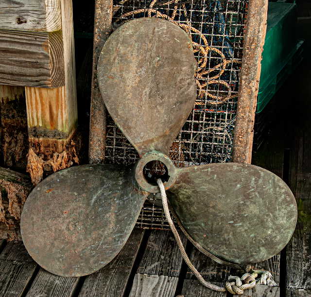 |
Old Prop - Southwest Harbor, Maine
Copyright Andy Richards 2009 - All Rights Reserved |
THAT IS pretty much what I know about Acadia National Park and the surrounding area. It is a place I really want to visit again. Hopefully some day soon. If it is not on your "photographic bucket list," it should be. Good shooting!


.png)


No comments:
Post a Comment
PLEASE COMMENT