This guide is a little different than the others, as I have combined several sites in one guide. For the most part, these have been short visits (mostly day trips), and a couple of them are probably half - day trips. My visits to these parks have been primarily day visits, so my experiences are short. But I include them because I think they all have some merit for photographers. With the possible exception of Shenandoah, I think they are all "day trips." Photographic opportunities are limited, but worth the visit. For more than 30 years my mother in law and brother in law lived in the suburbs of Washington, D.C., mostly in an area referred to as NOVA (Northern Virginia), west of the Potomac River. All but one of these parks were within just a few miles of us and I had several opportunities to visit them over the years.
Shenandoah National Park
I have been in this park just 2 times; both of them some years back. One was a day trip during the summer and the other, a long weekend in October. The majority of my time was spent on Skyline Drive, the only NPS road that runs through the park from Front Royal, Virginia all the way to the north end of The Blue Ridge Parkway (105 miles), at Waynesboro, Virginia. This park is primarily a hiker's park, in my opinion. By this, I mean that you will probably not find a lot to photograph by just staying with your car, and parking in the viewpoints. Having said that, I have only made a couple hikes, one up the mountain, and one shorter one, just back into one of the meadows to a wooded portion. Probably makes me unqualified to call this a "guide," but there might be a tidbit or two you could take away from it anyway.
The Blue Ridge Parkway, often confused with Skyline Drive, a continuation as you exit Shenandoah National Park at its southern border. The Blue Ridge is a separately administered unit of the NPS and not technically within Shenandoah National Park. It begins at Waynsboro (20 miles west of Charlottesville, Virginia) right where Skyline Drive ends, where the roads cross Interstate 64. The Blue Ridge is a nearly 500 mile drive that reaches all the way down to Cherokee, North Carolina at the entrance of the Great Smoky Mountain National Park. I have not driven it, but it should probably be on eveyone's bucket list.
Directions: Most people will likely approach the north end of Skyline Drive, at Front Royal, Virginia, from the Washington, D.C. metro area. The route is pretty straightforward. Find your way to U.S. route 66 and follow it west to Front Royal. Depending on where in the D.C. area you get on, during workdays, you can expect heavy traffic and congestion on 66 until well west of D.C. It is a major commuter route and can have bumper-to-bumper traffic during rush hour, at least as far west as Gainesville (just west of the Manassas Battlefield National Park), and sometimes even further out. Eventually, the traffic will thin and it is a pretty nice "country drive" the rest of the way to Front Royal. On the map, if you get off at the Front Royal interchange and take U.S. 522 south (N. Shenandoah Avenue), and find your way to North Royal Avenue (kind of around a curve) and take it right through town, it will turn into U.S. 340 and the Skyline Drive interchange is just south of town, off 340. Best to set your GPS for Skyline Drive and let it take you the best way (as I noted above, its been a few years). My recollection is that it is well marked. You could also approach it from Hagerstown, Maryland on U.S. I-70, taking U.S. 81 south from Hagerstown. At Winchester, you can either continue south on 81 to the interchange of 81 and 66 (and follow 66 back east about 7 miles to Front Royal and 522) at Middletown, or get off 81 at Winchester on to 522 and take it all the way south for 14 miles to Front Royal. I have not done either, but the second one looks to be a nicer drive.
I spent one evening shooting in Shenandoah, which involved a climb up a trail for a view of the mountains at sunset, and a few hours the next morning, beginning before sunrise and ending when it just got too bright for decent photography. I will hit my own points, but I think this will mostly illustrate a few opportunities for photography and a good guidebook or two would be a really good thing to consult for this park.
Somewhat different from a lot of the parks, Shenandoah is a rather narrow park that runs north to south along the ridgeline of The Blue Ridge Mountains. There are multiple hiking trails along the way, a few of them down to waterfalls and rustic cabins. If you are willing to hike on some of the trails, there are waterfalls and even some rustic cabins along some of the trails. There are also camping sites (though I believe camping is by permit). There is an entrance fee to the park (1 - 7 day passes are available). Most people generally just drive the 100 mile scenic drive. Because I was there on an overnight (we stayed in the NPS lodge at about the 50 mile mark), I was able to do a sunset and some sunrise and early morning light shooting. There are two fairly large facilities right near the middle of the drive: Skyland (where we stayed) and Big Meadows. Both have "rustic" cabin type accommodations (which really aren't rustic at all). The also both have nice restaurants. The occasion for my overnight visit was celebration of our anniversary, and my wife and I had a very nice dinner there.
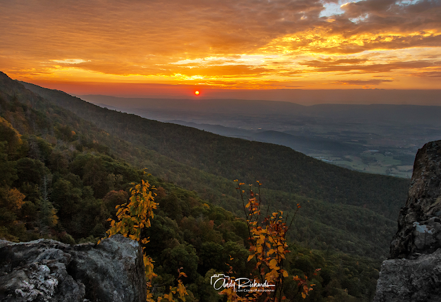
Stony Man Overlook
There are named and mapped "overlooks" in the park which could provide some possible sunrise/sunset landscape scenes. Quite near the Skyland Lodge is the trailhead up to a panoramic view from the second highest peak in the park: The Stony Man Overlook. In July, my brother in law and I took a "day trip" up to the park from his home in suburban Washington, D.C. After driving about 1/2 of Skyline Drive from Front Royal down to the Skyland Lodge, we decided to make the hike up to Stony Man. It is just over 3 miles round trip. Other than a substantial grade (that had us breathing hard even back then), it is not a difficult hike. The trail is rocks and dirt, but well maintained and marked. From the top you have a pretty spectacular view out over the park.
 |
Stony Man Overlook - Shenandoah National Park, Virginia
Copyright Andy Richards 2007 - All Rights Reserved |
I determined that afternoon that when we returned to the park in October, I would plan a sunset shot up there, as the view is to the west, weather permitting. Mother Nature Cooperated, and I got my sunset shots.
 |
Stony Man Overlook - Shenandoah National Park, Virginia
Copyright Andy Richards 2007 - All Rights Reserved |
I had imagined one of those layered, blue series of mountain ranges fading off into the distance. After, I was in the Blue Ridge Mountain Range. I didn't really get that and it would not be until more than 15 years later, when in 2023 I finally got one of those in the Great Smoky Mountain National Park. I felt like I got close at Stony Man, but that beautiful orange sunset actually worked at odds with the blue I was seeking. Not that that is a bad thing.
 |
Stony Man Overlook - Shenandoah National Park, Virginia
Copyright Andy Richards 2007 - All Rights Reserved
|
Knowing there were bears and other wildlife in the vicinity, my hike back down in the dark was a bit spooky. I had a headlamp and tried to make as much noise as I could as I walked back down. It was uneventful, and I am sure anything out there knew I was coming long before I would have ever spotted them.
 |
Sunrise on Skyline Drive - Shenandoah National Park, Virginia
Copyright Andy Richards 2007 - All Rights Reserved |
The next morning I was up before daylight and slowly driving south of our accomodations at Skyland on Skyline Drive. I knew there was wildlife in the park and I knew it was rutting season for deer and a time for finding food for bears. I have mentioned here on the blog that I am not a wildlife photographer. But even had I been totally prepared for what I saw that morning, I could not possibly have photographed it. It was still just barely getting light when I saw a momma black bear and her two cubs cross the road in front of me. As they scrambled up the bank, momma stopped, turned and looked a her two cubs following her. I will always remember that sight. Later that morning, still well before useable daylight, I heard a mysterious and rather loud clicking sound. It turns out that two young bucks were sparring - again, right in the middle of the road. Once again, there was simply not enough light to record that event. But a memorable morning for wildlife viewing.
 |
"God Beams" - Shenandoah National Park, Virginia
Copyright Andy Richards 2007 - All Rights Reserved |
I really didn't find any place great for a sunrise, and the morning was kind of hazy and overcast for the most part anyway, so I just stopped in a couple of spots where there was a view and made a few shots. In one case, I wandered down a dirt road just to see what was there and made the image below with the "god-beams." I have used that image a few times as blog title page background.
I think that's the kind of park Shenandoah is. Wander and find your own photos. I am not aware of any iconic spots in the park.
Manassas Battlefield National Park
This is another park where, for the most part, you will find yourself just wandering around the park and finding photo ops. For several years my brother in law owned a home very close to this park and I was able to visit it several times.
 |
The Stone House - Manassas Battlefield National Park - Manassas, Virginia
Copyright Andy Richards 2007 - All Rights Reserved |
Directions. This park kind of sneaks up on you right in the middle of the rather bustling and fast growing urban area of Manassas. All the spots I describe here are just to the northwest of U.S. 29 (Lee Highway), along an 8-mile stretch between two major interchanges with U.S. Interstate 66 (a major artery through suburban Virginia and into Washington, D.C., that was built a number of years ago now, to carry the traffic that used to be all on 29). For most, probably the easiest access is to take 66 from the east and get off at the 66/29 interchange that is just past a larger interchange with multiple highways, in or near Manassas - or from the west, get off at the Gainesville interchange. Both will take you onto Lee Highway. There are small parking areas at The Stone Bridge and at The Stone House. From Manassas, heading southwest, the first site is the Stone Bridge. It is marked and there is parking there. The bridge is a short walk from the parking lot.
Like Shenandoah, there aren't really any iconic photographs in this very small park unit. The closest might be the stone house, which played a part in both battles in Manassas and Bull Run, as a hospital for field casualties. Built sometime in the mid-1800's, it has stood the test of time. It is also very picturesque.
 |
Stone Bridge - Manassas Battlefield National Park - Manassas, Virginia
Copyright Andy Richards 2010 - All Rights Reserved |
From the small parking area, the trail out to the battlefield takes you across the stone bridge over Bull Run. The park is small, and other than the above, I think it is one you walk around and look for photos to make. |
| Manassas Battlefield National Park - Manassas, Virginia |
As you walk the battlefield, you see and might photograph canons (most likely set for decorative effect), and an old farmhouse.
Great Falls National Park
This is another one of the rather small administrative National Park properties. Obviously the prime scene here is the powerfull waterfall (actually a series of drops as the Potomac River makes its way toward the Atlantic. The park is actually in both Virginia and Maryland - the states split by the river. I have visited the park on both sides and you can approach the river and the falls from either side. But I think the Virginia side yields a better photographic perspective. I have spent several mornings in the Virginia side of the park. In both cases, there will be paved parking and it is a minimal walk to the river.
Directions: These locations are situated right in the heart of the D.C. Metro area, just west of the U.S. I-495 ("Beltway"). As noted with the I-66 route to Front Royal, in and around D.C. and the Beltway will at certain times be some of the most congested traffic you will ever experience. Anywhere. Over the years, the D.C. metro area has suffered some of the biggest expansion of any metropolitan city. The original infrastructure (including the Beltway) wasn't designed for the shear volume of traffic that it has to support, and consequently, there are times when gridlock is inevitable. For many years, my mother-in-law, and my brother-in-law lived in the area (including at times, Maryland and Northern Virginia) and most of my drives to the park(s) were from the Springfield area and thus along the Beltway. As they say on-line, "YMMV." Unless you are staying or visiting in the immediate area of the Park (Great Falls, Virginia, or Potomac, Maryland), you will need to find your way to the Beltway (495). In my own instance, I usually left the house quite early in the morning and usually dodged the worst of the traffic - sometimes taking some of the "minor" roads.
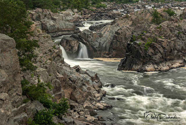 |
Great Falls - Great Falls National Park - Great Falls, Virginia
Copyright Andy Richards 2009 - All Rights Reserved
|
Virginia Side: Take the Beltway to 193 (Georgetown Pike) and take 193 west (of course if you are coming from anywhere around 193 you may be able to skip the Beltway part - do that if you can). Follow 193 (just over 4 miles from the Beltway exit) to Old Dominion Drive and turn onto Old Dominion northbound (right). It is just about 1 mile to the parking lot (which is a large, paved lot). There is a fee to get into the park, but the times I have been there have been early morning, and there has never been anyone (or any way) to collect the fee. I have parked and gone on about my shooting, without ever seeing a park official. My plan was to pay when somebody showed up - but it never happened. There are well-marked, mostly paved or well-improved trails down to the edge (note you are up on a high cliff here and there is fencing and signage warning of the dangers of climbing and falling. But the view is from up higher anyway. There are three marked "overlooks" on the Virginia side. My favorite - and I think the one that provides the best perspective for a photographer, it the southernmost overlook (#3). When I was there in 1997 for the first time, these overlooks weren't all there. The #3 was not, for sure. Instead, I stood on the ground along the fenceline to get a perpective of perhaps the primary drop in the area, known locally as "The Spout." The morning I was there, I was doing landscape shots when suddenly these kakers appeared. I was basically unprepared for them, but managed to get off a shot or two anyway. It shows some context regarding recreation on the river, and I love the red colors.
 |
"The Spout" - Potomac River - Great Falls National Park - Great Falls, Virginia
Copyright Andy Richards 1997 - All Rights Reserved |
Maryland Side: There are a handful of small roads leading in and up to the Great Falls area here. My suggestion (unless you are already familiar with the area) is to again approach it from the Beltway (495). There are two exits on the north side of the Potomac River which are close together and you could use either. But beware. The I-495 bridge ("The American Legion Bridge) divides Northern Virginia and Maryland, and is multiple, often congested lanes each way, and the first exit is just a few hundred feet across the bridge, so you want to be to the right - and ready. The first exit (is for Clara Barton Parkway/Carderock). It happens very fast. If you miss it, no real worries, just stay right on the Beltway and get off at the next one, which is the Exit for River Road/Potomac. If you made the first one, just get on Clara Barton Parkway westbound. In about a mile, it merges onto McArthur Blvd. Follow it another 4 miles to the Billy Goat Tavern Great Falls Visitor Center. If you miss the Clara Barton exit, take the next one and head west toward Potomac, Maryland on River Road (190). In just over 3 miles, you will come to Falls Road (right in the middle of the little berg of Potomac). Turn left (south) and follow Falls Road for 2 miles down to McArthur Blvd. Turn west (right) and the Visitor Center will be one mile from your turn.
Once you find the Visitor Center, you can park and walk to the Falls Overlook, or even several other areas. The center sits right near where the C&O Canal begins, off the Potomac. There are two feature worth wandering around there. First is the C&O Towpath (in the days when it was in use, they used mules on the path to tow barges in and out of the D.C. area). When I lived out there, there was a concession that had the barges made into passenger boats and you could pay to get towed for a portion of the canal, with a guide. Either way, there are some potential photo ops. The second feature is the popular Billy Goat Trail, which is a trail along the river and canal for about 5 miles. It is marked "easy to difficult." LOL. Helpful? I have walked parts of it out to the river and the part I was on wasn't that difficult - I carried my camera and tripod out there. Best thing here is to consult a good map as the river splits in places and depending on foreground foliage, might yield up some nice photos. It is an area you can spend some time at. Explore. Sadly, my own photos of the area were made during the film days and my archive system - frankly - sucked. I only have memories. But it is worth at the very least, a day trip.


No comments:
Post a Comment
PLEASE COMMENT